INTRODUCTION
DIM2SEA research program aims to increase urban resilience to large scale disasters, both natural and anthropogenic.
We aim to develop a prototype Dynamic Integrated Model for DIsaster Management and Socio-Economic Analysis (DIM2SEA) that will give disaster officials, stakeholders, urban engineers and planners an analytic tool for mitigating some of the worst excesses of catastrophic events. These events can be natural disasters such as hurricanes, storm surges, typhoons, tsunamis and forest fires, or man-made shocks such as industrial accidents, warfare and terror events or any combination of the two, as witnessed in the 2011 Tohoku earthquake, tsunami and nuclear power accident in Japan.
This is achieved by harnessing state of the art developments in spatial analysis, simulation modeling and GIS.
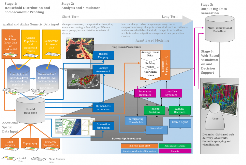
Our focus is on enhancing disaster response and socio-economic resilience. We are particularly interested in the differential socio-economic impacts of disasters on sub-sectors of the population and on the long term system-wide effects on the urban environment an issue that has received scant attention in the past. In this respect, we fill an important gap in both technology development and disaster management practice. The proposed model will be able to combine both short term damage assessment, evacuation routing and transportation disruption along with longer term assessment of urban dynamics post-disaster. While the former focuses on damage and casualty estimation, the latter includes land use change, shifts in urban morphology and changes in urban social and demographic composition.
METHODS
The method to be employed combines the latest ICT developments for spatial analysis: remote sensing, location optimization, damage assessment, agent based simulation, GIS-based socio-economic profiling and the web-based delivery of results using dynamic mapping.
At the heart of our approach is a dynamic agent based model coupled with post-disaster damage assessment and a socio-economic profiling algorithm. The former simulates the effects of the disaster. The latter allows for assigning detailed socio-economc attributes to the population at risk when spatially accurate data is not available. The large amounts of simulated spatial and temporal data generated by the agent based model are fused with the socio economic profiles of the target population to generate a multi-dimensional data base of inherently 'synthetic' big data. Results are made accessible to the engineer and planner through web-based delivery in an intuitive and non-threatening manner. The proposed DIM2SEA model will result in an integrative disaster management tool with a level of spatial and temporal detail that hitherto has not existed. The model itself can be used for real-time analysis as well as for ex ante training and simulation exercises.
THE RESEARCH PROJECT GROUP
The project pools the combined expertise of the two groups. Work is undertaken by both groups in parallel. Two annual product development meetings are due to be held in Japan and in Israel for co-ordination. Scientific workshops will be conducted in both countries to share research progress and outcomes.
Figure 1: The DIM2SEA Model Framework
(for more information see the research proposal on this page)

")
